The two biggest challenges for yacht cruising are weather and navigation. In the south-western Pacific, most voyages are less than seven days, roughly the horizon for weather forecasting using GRIB files. I'll discuss that another time.
Navigation has become much easier since we have had GPS satellites. Especially since the Clinton/Gore government generously ended the US Government practice of 'Selective Availability (SA)' under which a deliberate error was introduced to give the US an advantage over potential enemies. SA was turned off in 2000, which had the effect of increasing the accuracy for navigation by GPS from 100-200 metres to something like 10 metres. Ten metres is fantastic.
Unfortunately, there is still a fly in the ointment. Although we know where we are to about ten metres by satellite defined position, the charts in the Pacific are often out by up to two miles!
This can produce a rude shock to yachties who have become used to trusting their chart-plotters. We can be sublimely confident in our position when a big bang indicates that the Earth is not where it is supposed to be! Modern electronic charts are mostly derived from old charts drawn before GPS. Our current uptodate charts were based on a survey conducted in 1898!
There are various solutions.
1) Give much greater allowances to reefs and rocks than we are used to doing.
2) Use radar to compare the position of an echo from a cliff with the line of the same cliff on the chart. When there is a discrepancy, look out!
3) Use multiple sources of information, don't trust only one.
4) Use charts derived from screenshots from Google Earth photo imagery, which is geo-located using GPS, not old charts.
Google Earth navigation is rapidly coming of age. I thought I would write a brief tutorial on how we are using it.
I have plagiarized some of the pioneers of this technique in a separate website:
My laptop is a MacBook Pro. It can run the OpenCPN navigation software, but the software to generate new KAP files from Google Earth only runs on Windows. If you want to generate KAP files for another part of the globe, you will need to borrow a Windows computer with as high a resolution screen as possible, and then create tiles of geo-referenced KAP files using Google Earth Pro (which recently was released free, instead of costing about $400 per month! The software to automate the tiling is called GE2KAP. It can be downloaded here.
You can also download previously created KAP files, with which you can try the system out. Soggy Paws is a boat whose owners have produced quite an archive. Find it here. It is possible to make much higher resolution images if you do it yourself.
A useful trick can get around one problem with Google Earth images. Sometimes the photo has a cloud covering a crucial area. By playing with the 'History' option, you can move back in time until you find a photo that was taken on a fine day.
Lots of people swear by OpenCPN. It works, but seems pretty clunky to me. At times I want active plotting with my boat icon moving fluently along its track, and suddenly, for no apparent reason, my active red icon becomes a grey zombie, and stays stuck at its last known location.
I have found a better program for displaying Google Earth charts is the free iPad app SEAiq Open. It seems faster and more robust than OpenCPN, and uses the same KAP files. Full instructions can be found by opening the app, selecting 'Charts' and opening the 'Help' ? section.
See also below a Chinese app for the iPad called Ovitalmap, which I discovered since writing this part of the blog. Download the app here.
See also below a Chinese app for the iPad called Ovitalmap, which I discovered since writing this part of the blog. Download the app here.

This is our rig. Mostly I use the Raymarine chartplotter, with the fishfinder page also active if we are considering anchoring and I want to see the quality of the bottom. When I get to a new area, I put on the radar to compare the images from the radar with the images from the Navionics charts.
The MacBook Pro, with its USB GPS aerial attached to the window above it, is running OpenCPN with Google Earth charts converted to KAP files.
The iPad is running SEAiq Open, using its built-in GPS receiver. It is also showing Google Earth images. It also carries books such as a local cruising guide, a different Navionics chart, etc.
The system worked really well when we had to leave northern Ha'apai at 10 pm at night. We were anchored inside some coral reefs, and had to work our way out past some bommies without being able to see them in the dark. Using the 'Track' line on the chartplotter which recorded the way we entered, and the Google Earth images of the bommies on the iPad, we got out safely.

Warning!
Both Navionics and Google Earth have their deficiencies.
Check out these.
The Navionics chart on the iPad and also the Raymarine chartplotter showed this bay as looking like this.

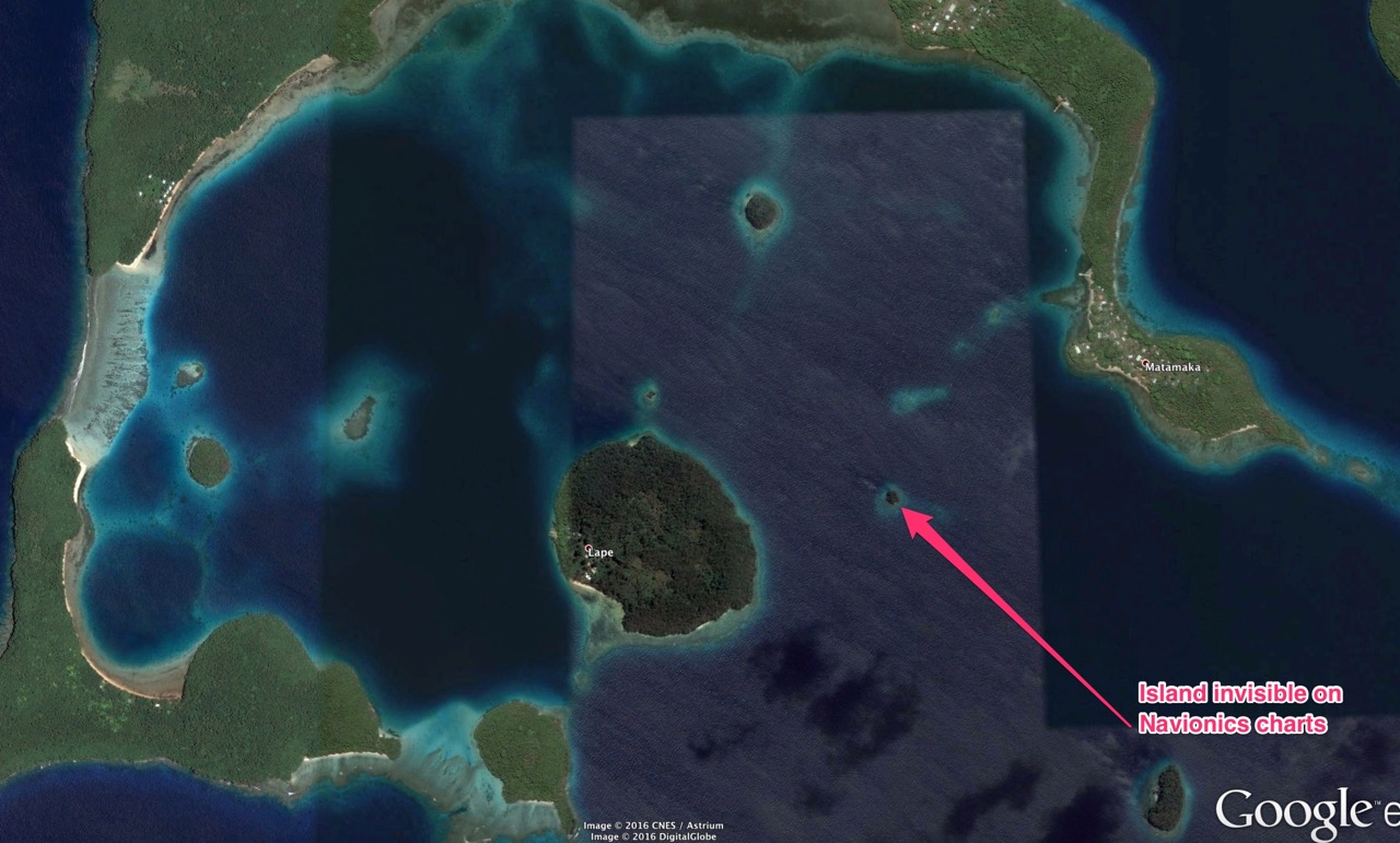

Island very visible, with 50 metres of coral around it.
I contacted Navionics, and they told me to update my charts for this area. The result is below.
Slack updaters be warned. But also there is no doubt that this island had existed for years. There may well be more things in heaven and earth than Navionics has dreamed of.

After chart updating.

Close-up of updated chart.
So should we place our trust in Google Earth?
Consider this example.
One option for navigating between Vava'u and Savusavu in Fiji is to go through the Vanuabalavu Passage. Looking at Google Earth, with our new-found confidence in its superiority over Navionics, we see a clear passage 8 nautical miles wide between Vanuabalavu and a reef to its south. Easy peasy, right? Photos from the sky never lie, right?

Wrong!
Look now at Navionics and iSailor.

Malevuvu Reef is sitting malevolently in our intended path, completely invisible on Google Earth!

I think the message is that Google Earth shows things in accurate positions by GPS, but that there are significant gaps, or lacunae, in its coverage. Navionics mostly, but not always, shows things that exist, but the actual GPS positions might be inaccurate, especially if the surveys on which the charts are based are old and pre-satellite geo-location.
Caveat Navigatores!
I came across a new meaning of the acronym SNAG. Satellite Navigation Assisted Grounding!
Uncharted Reefs
If the above doesn't make you nervous, a friend kindly referred me to an article about uncharted reefs in MySailing. 'Uncharted Reefs in Tonga and Fiji'.
It contains 60 waypoints for dangerous reefs. I put them all into Google Earth, and have saved a folder of them so you shouldn't have to do it yourself.
Uncharted Reefs. Click this and the waypoints should open in your Google Earth.
Postscript.
I came across a blog Zero2Sixty which contains a very useful article: Navigate the Pacific Despite the Bad Charts. It also gives a link to a Chinese app for iPad which assists the downloading of Google Earth and Bing satellite images for navigation purposes when off-line. Very useful. OvitalMap.
Good article 'How to make navigation safer using satellite images', by Chris Beeson in Yachting Monthly, March 2016.
Hi Dave - wa s just reading through Jon Hacking's excellent post on KAPs and saw GE2KAP only runs on Windows. So I scrolled through your old posts and you confirm this is so. So how did you downloaded your KAPs for use on your Mac? Did you download the KAP (via a Windows computer) onto an external hard drive and then plug that into your Mac? Did you experience any problems or have any tips?
ReplyDeleteYes, Bruce. That's exactly what I did. I went back to the dark ages and borrowed a Windows laptop from a friend (with whom I have a longstanding Win-Mac joshing rivalry) who took the opportunity to take a few humorous free kicks at me. The main trick I can remember was that the GE2KAP program somehow reads the screen resolution of the computer you are using to determine the resolution of the KAP files it produces. The Windows laptop I borrowed was not particularly hi-res. Try to borrow one with a big hi-res screen to do your map capturing.
ReplyDelete