A new survey has been performed by MSQ, and reported on 4th May 2017.
Here is a section of the survey.
The directional light on Hook Point has been moved to a bearing of 270/090. As you can see below, that takes you over about 500 metres with less than 5 metres depth; the minimum depth being 3.7 metres.
My own view is that the light should be ignored, and waypoints should be published regularly by MSQ.
An alternative route crosses a narrow spot with a minimum depth of 5.0 metres
Looking at the latest survey, reasonable waypoints would be:
1) 25° 47.7'S, 153° 08'E,
2) 25° 46.8'S, 153° 07'E,
That would keep you in water more than 5 metres deep.
A more complex option that is still reasonable, would be to put in some extra waypoints.
First Waypoint A = 25°48'S, 153°08'E,
Second Waypoint B = 25°47.23'S, 153°07.38'E,
Third Waypoint C = 25°47'S, 153°07'E,
Fourth Waypoint D = 25°47'S, 153°06.73'E, On line of Inskip Point leads.
Fifth waypoint E = 25°48'S, 153°05'E, near Inskip Point.
First Waypoint A = 25°48'S, 153°08'E,
Second Waypoint B = 25°47.23'S, 153°07.38'E,
Third Waypoint C = 25°47'S, 153°07'E,
Fourth Waypoint D = 25°47'S, 153°06.73'E, On line of Inskip Point leads.
Fifth waypoint E = 25°48'S, 153°05'E, near Inskip Point.
All at your own risk. Check with Tin Can Bay Coast Guard (Tel: 0419 798 651).
This photo was taken by a pilot flying over the area on a calm day; 5th August 2018.
This photo was taken by a pilot flying over the area on a calm day; 5th August 2018.
To check for an update to this survey, go to the Maryborough: Notices to Mariners site.
Search for Wide Bay Bar.
A new survey was performed on 29th September 2018.
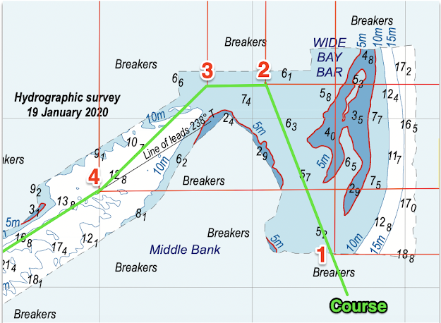
A further survey was done on 19th January 2020. Download it here.
Waypoint 1 - 25˚47.8' S. 153˚7.55' E.Waypoint 2 - 25˚46.8' S. 153˚7.1' E.Waypoint 3 - 25˚46.8' S. 153˚6.7' E.Waypoint 4 - 25˚47.4' S. 153˚6' E.
These waypoints are derived from the graphics of the survey above. Use at your own risk, and check with Tin Can Bay Coast Guard (Tel: 0419 798 651).


