A new survey has been performed by MSQ, and reported on 4th May 2017.
Here is a section of the survey.
The directional light on Hook Point has been moved to a bearing of 270/090. As you can see below, that takes you over about 500 metres with less than 5 metres depth; the minimum depth being 3.7 metres.
My own view is that the light should be ignored, and waypoints should be published regularly by MSQ.
An alternative route crosses a narrow spot with a minimum depth of 5.0 metres
Looking at the latest survey, reasonable waypoints would be:
1) 25° 47.7'S, 153° 08'E,
2) 25° 46.8'S, 153° 07'E,
That would keep you in water more than 5 metres deep.
A more complex option that is still reasonable, would be to put in some extra waypoints.
First Waypoint A = 25°48'S, 153°08'E,
Second Waypoint B = 25°47.23'S, 153°07.38'E,
Third Waypoint C = 25°47'S, 153°07'E,
Fourth Waypoint D = 25°47'S, 153°06.73'E, On line of Inskip Point leads.
Fifth waypoint E = 25°48'S, 153°05'E, near Inskip Point.
First Waypoint A = 25°48'S, 153°08'E,
Second Waypoint B = 25°47.23'S, 153°07.38'E,
Third Waypoint C = 25°47'S, 153°07'E,
Fourth Waypoint D = 25°47'S, 153°06.73'E, On line of Inskip Point leads.
Fifth waypoint E = 25°48'S, 153°05'E, near Inskip Point.
All at your own risk. Check with Tin Can Bay Coast Guard (Tel: 0419 798 651).
This photo was taken by a pilot flying over the area on a calm day; 5th August 2018.
This photo was taken by a pilot flying over the area on a calm day; 5th August 2018.
To check for an update to this survey, go to the Maryborough: Notices to Mariners site.
Search for Wide Bay Bar.
A new survey was performed on 29th September 2018.
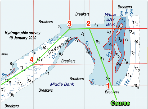
A further survey was done on 19th January 2020. Download it here.
Waypoint 1 - 25˚47.8' S. 153˚7.55' E.Waypoint 2 - 25˚46.8' S. 153˚7.1' E.Waypoint 3 - 25˚46.8' S. 153˚6.7' E.Waypoint 4 - 25˚47.4' S. 153˚6' E.
These waypoints are derived from the graphics of the survey above. Use at your own risk, and check with Tin Can Bay Coast Guard (Tel: 0419 798 651).


Thanks this was very helpful. Just completed cruising using your two waypoints. Agreed with you interpretation of the recent survey. Momentarily got to 5.5mtrs Inc 1.5mtrs tide. Thanks again
ReplyDeleteHas there been any update to this information?
ReplyDelete